Monday, November 29, 2010

Way-Finding Without Maps

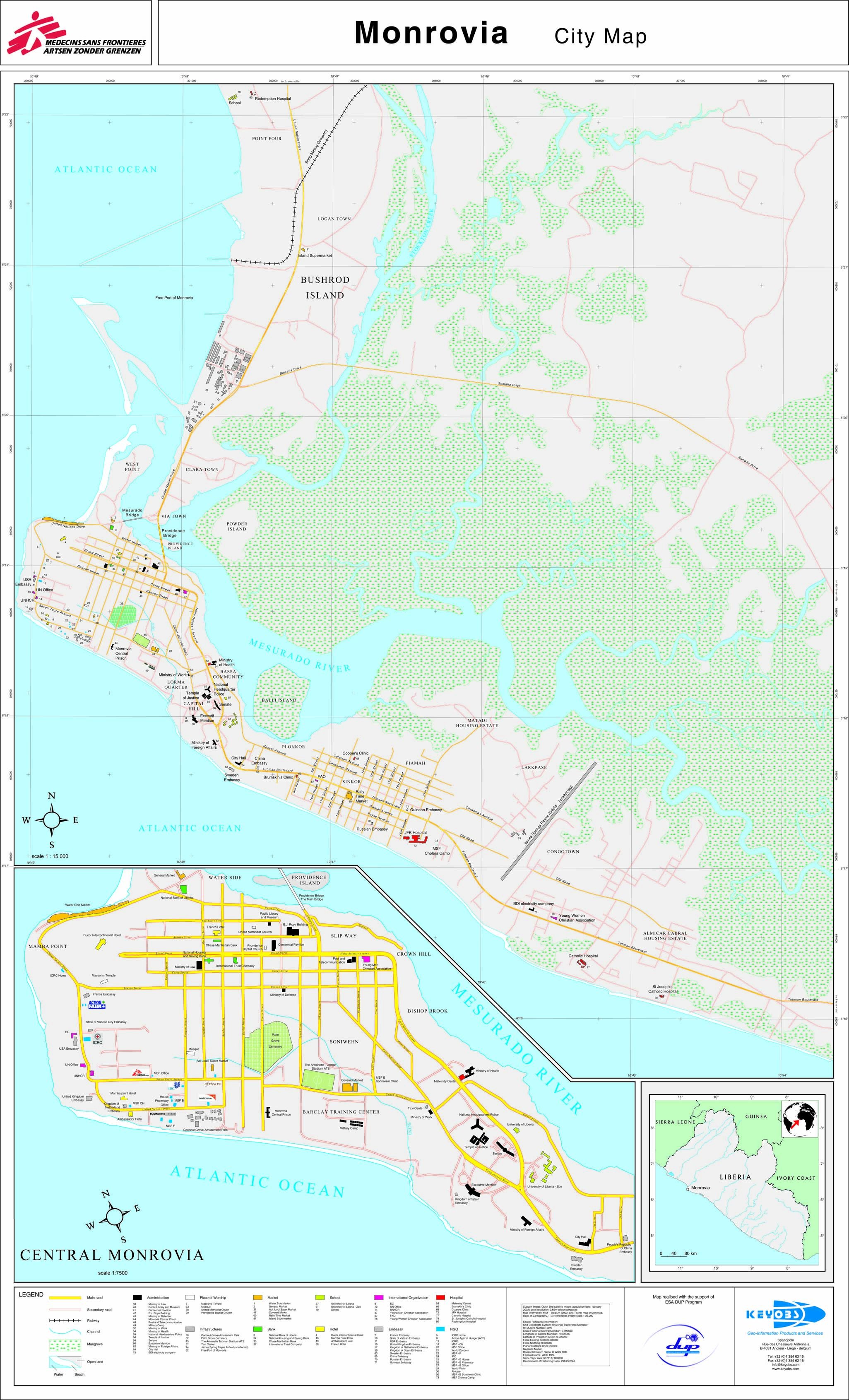
Aside from all the usual reasons why improving the available maps of a city would be beneficial to its residents and visitors, in the case of Monrovia it is especially important, because Monrovia's street address system is undeveloped and under-functioning.

At some point a few decades ago, the city seems to have had a numbered street-address system, which, at least downtown, is still nominally in place. There is no postal delivery service in Liberia the moment, so these numbers have use only in the sense of the general public way-finding in the city. Although numbers appear on business cards and signs for many businesses on the main avenues in the Broad Street area, it is rare to be told a specific street number when directions are provided.

This is partially a result of Monrovia's small size, there are only so many streets and buildings on them. But Monrovia, like many cities in West Africa, has an only partially-developed official street-naming system. Street address numbers are few and so locations are presented in relation to landmarks. This is especially true when the location of the dwelling or business is unofficial, or informal.

Thus addresses in Monrovia are rather vague, often just listing the name of the street and section of town. Businesses and residences are often listen simply as Smythe Road, Old Road; 12th Street, Sinkor; or UN Drive, Mamba Point, so that the location is specified to within several city blocks.

This is mitigated partially by the profusion of signs, labels, and graphics painted on or affixed to structures large and small, which almost universally proclaim the name of the street, area, or neighborhood. In many cases a post office box number is provided for mailing-- the only way to expect any type of letter-carrying in the country. In a limit-technology environment, such signage is often the only advertising a business has, and for a visitor, obtaining bearings is eased because of the proximity of signs proclaim the name of that particular street and neighborhood.


T. Choithram & Sons at Red Light, with four signs, address on the top.

What Monrovia lacks in street numbers it more than makes up for in landmarking. Most prominent buildings are named. In fact, a great many large buildings in the capital have more than one name. For the most part, these fall along the lines of the following:

(1) A name is given to the building by its owners, this is often a family name; (eg Parker House; King Building; but also perhaps first names, eg Diana Plaza; or the Rose Building. Presumably these are owned by such individuals or families.

(2) A name is given to a building based on the business that is presently there (eg Lonestar Building, Cellcom Building, Star Radio Building, American Laundry Building, Fedex Plaza). Often these are buildings built by that particular business.

(3) name given to a building based on the business that was once there, which includes such examples as Chase Manhattan Plaza, among others.

This last category can be especially confusing as it often presumes that the wayfinder has either been resident in Monrovia for several decades, or knows the commercial history of the town during this period well-enough. For instance, the DHL office on Broad Street is in the Old Mandarin Building, a named derived from an erstwhile Chinese restaurant in the stately, settler-era mansion, whose appearance suits the gradiose moniker.

The Sport Commission is a major landmark at the Crown Hill
end of Broad Street.


The King Building, on Broad Street at the corner of Gurley Street.
Note the P.O. Box number


Horton Avenue is only a block long. Note the street signs, still relatively uncommon,
and also the JSI sign designating the building name.


Exclusive's original in-town location is noted as Carey & Gurley Streets on the sign above the corner.


Farther out in Paynesville, these informal businesses are noted as simply "ELWA Junction"


Diana Plaza, Broad Street


The E.J. Barclay Building at Carey & Johnson Streets has also begun to be referred to as
the "Caesar Architects Building" due to this prominent sign. Note building number.

Archaic nomenclature can make things even more confusing; but can also be insightful to Monrovia's geography and history. For instance, I was once nearly very embarrassed by my tardiness to a Sunday service at a Baptist church across in the Freeport area of Bushrod Island. I had been invited by a colleague, eager to impress, and had been told to have the car "put me down at the Old Peugeot Garage." So I started looking among the many commercial signs in that stretch of road for a Peugeot dealership.

Little did I know that the Peugeot Garage was referred to as "Old" because it had not been there in about twenty years, so only the people who knew of its previous existence could use it as a road marker.

The situation is even looser when paved streets and concrete buildings with names and signage are not involved, which is the case for the majority of the city's residences. On my first visit to Liberia two years ago, I asked my new friend for his address. Here is what he wrote down:

Kpelleh Town, Rock Hill, ELWA Community, Paynesville, Liberia.

This may seem impossibly vague, like presuming that if you said Murray Hill, Manhattan, New York, someone could find the way to an apartment there. But here's how it works: first, go to ELWA in Paynesville, and generally head towards the northeasterly zone off the highway-- this is the ELWA Community. Ask around where Kpelleh Town is, and someone will either point you in a direction, or escort you to the general area. Once at Kpelleh Town, ask where the Rock Hill section is (or, as my friend told me, look for people breaking rocks, which is the equivalent of telling someone to go to the tip of Manhattan and look for people carrying briefcases). Once you are reasonably sure that you are on Rock Hill, ask for your acquaintance by name, and be pointed or escorted to the correct house.

Like many aspects of life in Monrovia, although it can be confusing, time-consuming, and often frustrating, it is also insightful into a way of orientation which hardly exists in the US, even before the era of GPS. There is often no way to find a business or person without the assistance of one or more of a series of locals, who are normally abundantly friendly and helpful.

Wednesday, November 17, 2010

Mapping Monrovia


As readers of this blog, and visitors to the Moved 2 Monrovia website come to find, I've really developed an interest in Monrovia's history and geography. I have even drawn some maps of my own, which I have been developing into a handy tourist map of the city--I hope to be able to announce details of this soon.

While maps of the city are available on-line, none of them are very accurate; misspellings and other mistakes are common, and some of the information that is provided is decades out of date. The current cartographic situation typifies those constraints common in tackling many of Liberia's challenges: suffering from an overhang of history, and lack of easily accessible and verifiable information, and needing more assistance (almost wrote "capacity building," but I'll spare you).

This is no more true than with the only atlas that matters in the world nowadays: Google Maps. The top image is a screen shot of Monrovia. Notice, for instance, how UN Drive is missing along Mamba Point. The below is a screen-shot showing the current, somewhat sorry state of Google Map Maker's representation of Central Monrovia. Its obviously suffering a rather glaring error, with a truncated Mamba Point, an amputated West Point, and thus most of the city's diplomatic community and largest informal community in the Atlantic Ocean, as if the city had experienced an earthquake (one of the few disasters West Africa has avoided). [ed: I have no idea why Google Maps and Google Mapmaker seem to show to different versions].

So clearly, this corporate crowd-sourcing cartography project is in need of some work, even if Monrovia, which saw almost no new construction in the last 20 years, still appears remarkably similar to how it looked half a century ago. The city itself is not the same as it was in the 1980s (quite aside from the new landmarks of the recent building boom). This is where the current state of Monrovia's Google Map is peculiarly intriguing : landmarks which were vacated, abandoned, or moved long ago remain on the map, like ghosts of history.

Presently, Google Map still shows such phantom landmarks as the Ducor Intercontinental Hotel and the French Embassy. I'm all in favor of including these on any map, as the hotel in particular remains one of the city's most important landmarks. But it should be clear to the map user that they shouldn't show up at the Ducor expecting a club sandwich and a dip in the pool, or at the French Embassy planning on getting an E.U. visa or taking in an evening Balzac lecture. Similarly, the eerily empty E.J. Roye building is included on the map.

I'm still getting the hang of the editing tools in Google MapMaker, so I am not sure if they have a "shell-of-its-former-self" category. Such post-colonial ruins, often found in post-conflict states, are too young to be archaeological, but also too recent to be historical, especially as they might be redeveloped.

Likewise the zoo, which I am pretty sure was never inside the Matadi housing estate as shown. I have been told it used to in an area called Mercury Field, near Gaye Town, Old Road, and is actually called Old Zoo. I recently deleted the zoo in the list of attractions in the Culture and Media section of the Wikipedia article on Monrovia. (Don't even get me started on how bad the Wikipedia article is.) But I'd hate to have someone wandering around Matadi, looking to watch a sea lion feeding.

Besides France, other former embassies are shown on the map, including the British, Swedish and Dutch Embassies. All of these are still standing, occupied buildings, but are no longer diplomatic missions. These states presently do not have any consular services in Liberia at all. Similarly, the Chinese embassy and many African commissions are shown in old locations.

Several government ministries have switched places-- there is no longer a Ministry of Work, and its replacement, the Ministry of Labor, is in a different location than shown. Same with the Ministry of Law, which is now the Ministry of Justice several blocks away. But even in the two years that I've been in Liberia, several ministries, like Defense, have changed location.

Prior to my first time traveling to Monrovia, I had trouble finding much to familiarize myself with the city (Google had yet to map Africa beyond blurry satellite photos on Google Earth). So I was thrilled to come across this MSF map, below, which is was created by the European Space Agency in 2003 (Thanks to UC Berkeley for the link: large format here). It includes a lot of helpful and practical information, and it gets some details right (Lorma Quarter), and some things wrong (those warehouses in Joenhansen were never Water Side Market, and Rally Time Market was never in Sinkor; also, the Old Road area is incorrectly labeled as Congo Town, which really confused me the first time I visited). There are also some spelling issues ("Executif Mansion"; "Massonic Temple") which seem to reveal its pan-European authorship.

It also features a lot of individual building details, which is helpful (yay, Abi Jouadi Supermarket!), but still has a lot of pre-conflict landmarks, like Chase Manhattan Bank, as well as the Swedish, French, Russian, and Dutch Embassies. I've never heard of the French Hotel, its definitely not there now. Also note how the original Old Road, which was split by the Spriggs-Payne runway decades ago, is still labeled as such, and not by its contemporary moniker, Airfield Short-Cut. Thus, the map is a mixture of information that was correct circa 2003, and another layer of information that was more accurate in the pre-conflict period.
A second example from the immediate post-conflict years earlier in the decade is below. The first image, showing Central Monrovia, highlights the old Embassy Row on Mamba Point, but not much else (and its Ashmun Street, not Ashmond). Also, there are a lot of names for "Across", on the upper-right, including Vai Town, Clara Town, Free Port, and Bushrod Island, but Riverview Section is not one of them.
The bottom image, of Sinkor, is mostly fine, except that every single embassy shown is not in the same location today (and of course Zaire is now the DRC; and by the way its Cheeseman Avenue, not Chessman). These seems to have been produced for the United Nations, which at least might explain the colors and the emphasis on Embassies.
Going further back into the pre-digital era, this rather basic, seemingly hand-drawn map below, from Lonely Planet, was basically the extent of publicly-disseminated maps the city available in a typical American library or bookstore (Thanks to U Texas for the link). Unfortunately, it is both sparsely detailed and somewhat misleading, without bothering to include the grid of Sinkor's "Avenues", much less the Old Road section of town, or providing much sense of scale (As an aside, its interesting to find that Lonely Planet now uses Google Maps on its website).
Posting this one reminds me: has anyone ever heard of the first section of UN Drive that passes Rally Time Market and the Barclay Training Center, referred to as Fairground Road? I've asked several generations of Monrovians, including my friend who grew up in Bassa Community. He did say there was once an amusement park in that area, possibly including a Ferris wheel (I've no other confirmation of this). Since the street and its carnival rides could have easily preceded the founding of the United Nations itself, I suppose its entirely possible that it had a former name.

What's also unique to this situation is the issue of authority. None of the above examples were directly produced by Liberia's government, and its not clear what input Liberians might have had in their production or fact-checking. Therefore, there is something of a vacuum when trying to determine if there is a correct way to spell Lakpazee, the northern area of Sinkor, which is spelled Larkpase in both map examples above. That may just be the way a European Space Agency technocrat typed it in.

Its difficult to be confident that geographic information is accurate, and therefore sufficient to improve the condition of Google's maps, for the benefit of others. It generally takes extra time and effort, and is hard to support assertions when trying to get contributions to Google Maps approved.

Despite this frustration, there is an upside to improving Monrovia's map which is very exciting and encouraging: like so many endeavors in Liberia, work can be pioneering a tangible improvement. Its not likely to come across mistakes and omissions when scanning Google Maps of Chicago, New York or Boston. In ways big and small, there is an opportunity to make a difference in a way that is hard to find an equivalent of at home in the U.S.

I'll close this now very long post with the below shot, the only image of a pre-war Tourist Map of Monrovia. From this tiny slice, it looks rather detailed and official. I'd love to see a copy of this someday, and see what is shows (thanks to Shelby Grossman for the original source, and all your on-going help with locating the original).

Until then, I'm going to try to figure out how to label Old CID Road onto Google Maps, for all the world to see.

Wednesday, November 10, 2010

Ohio In Liberia


Looking closely at the maps above, you can spot Mississippi-in-Africa, Louisiana, Maryland, and New Georgia. I had heard of all of these. I've also read about colonization societies from Pennsylvania, New York, and New England. But until I had seen the maps in the photos above, I had never head of an Ohio colony. Also notice how the Vai people are labelled "Veys", and more generally in both maps how the interior, not far in from the coast, is boldly labelled Guinea. Its also interesting that the town near to Ohio is called "Sugaree" which reminds me of my friend's hometown, Sugarcreek, Ohio.

In researching this, I came to learn that E.J. Roye was from Ohio, and that today there are several active Liberian communities in Cincinnati, Columbus, and Cleveland.

And I also found this document, dating from 1851, discussing the Ohio State legislatures commitment to the sponsorship for an Ohio-in-Africa colony. Six pages of fascinating reading of how arguments for Emancipation, Anti-slavery, and Christianity were the basis for advocacy of funding the establishment of Liberia's settlements.

I snapped both of the photos below on a recent visit to the offices of Dr Fred van der Kraaij, in the Netherlands Foreign Ministry in the Hague. FvdK has to be one of the main Liberia-supporters in the Netherlands, perhaps even in most of Europe. He spent many years in Monrovia in various capacities, but hasn't been back in almost twenty years. Nonetheless, he continues to show his support and enthusiasm for Liberia and its history through his excellent blog, Liberian Perspectives.
Tweets by @moved2monrovia